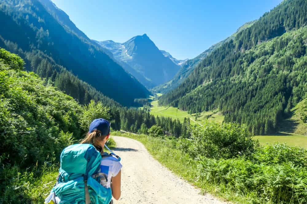
Switzerland is full of amazing hiking trails designed for all levels. For those of you who would like to enjoy the rich landscape of the country, add some salt to your trip or who simply want to enjoy a walk in nature, we have collected for you walking routes for all fitness levels that do not require equipment or technical knowledge, just you, a bag on your back and mountains on all sides. Please note that there are quite a few variations to most of the routes here, so if you want to shorten or extend these routes, in most cases you can.
Easy walking trails
These routes are intended for anyone who wants to enjoy an easy walk in the endless nature of Switzerland.
The routes do not include many ascents and descents and are relatively short (up to two hours)
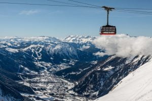
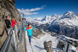
mount rigi panorama trail
The route goes along a scenic path on Mount Rigi and overlooks Lakes Lucerne and Tzog. The route can be done in all seasons, although in winter snow may pile up. In the spring the mountain is covered in all the colors of the rainbow and provides a great view
§ × × : Rigi kaltbad station
End point: Rigi Scheidegg
Length: 7 km
Estimated time: Two hours (the route can be extended)
Total ascents (in meters): 190
Total descents (in meters): 70
circular? No, you can make a return trip or get off at the cable car at Rigi Scheidegg and from there take a train back to where you parked.
ways of getting there: The route starts at the Rigi kaltbad train station which must be reached by train from Vitznau or alternatively with the cable car from Weggis.
Brief description:
After you arrive at the train station, follow the signs to Rigi Scheidegg, the path is very clear and goes along a ridge path, along the path you will climb about 200 meters until you reach another cable car (Rigi Scheidegg) which is your end point.. You can also do the route in the opposite direction.
For those who feel that the route is too short, the route can be extended in a variety of ways, the most popular of which is to take the cable car to Rigi Kulm and start the route from there to Rigi Scheidegg, on the way you will also pass through Rigi Staffel, this option will extend the route by an hour so that you will walk a total of 10 km, wait The highlight of this road is the 360 view you will get to see at Mount Rigi.
way back: You can take a cable car to Arth-Goldau and from there take a bus back to where you parked or alternatively retrace your steps back to the cable car from where you arrived.
the eiger trail
An amazing route that goes along the length of the Eiger glacier and provides some of the best views in the Alps. The route is mostly downhill, very clear and very comfortable.
§ × × : The train station of the Eiger Glacier (eigergletcher )
End point: Train Station Alphiglan (Alpiglen)
Length: 7 km
Estimated time: 2-3 hours
Total ascents (in meters): 140
Total descents (in meters): 800
ways of getting there: The route starts from the train station at the foot of the Eiger Glacier called the Eigergletcher. The station can be reached by train from Lauterbrunnen to kleine scheidegg and from there change to a train for a total of about 45 minutes. Or alternatively, take a cable car from Grindelwald called the eiger express which takes about 20 minutes. The faster way (also on the way back) is from Grindelwald.
Brief description:
After you have arrived at the train station you can admire the power of the glaciers towering above you, after you have finished photographing them from every angle you can turn to the path, follow the signs to the Alpiglen (Alpiglen) which tells you about a two hour walk, these times are for people who are in a fairly good walking condition and even then refer to net walking times No stops, by and large from here the path is very, very clear, the path goes along the length of the glacier towering above you and descends mostly (except for the last section) slowly towards the town, the easy walk takes about two hours and although the view does not change you will be moved by it every time you look up. After you reach the waterfall, you will start a steeper descent towards Elpiglen, after about 30-40 more minutes you will reach a train station.
way back: To return from the town to Grindelwald or Lauterbrunnen, simply arrive at the train station in the town, from where there are quite frequent trains that arrive to the two aforementioned towns.
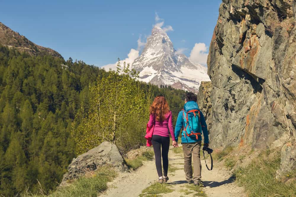
Rifflesee to Riffelberg
Those who plan a trip to Switzerland must be at the Gornergratt glacier and those who arrive at the Gornergratt glacier must visit the Rifefelsee lake, to be at the best vantage point of the Matterhorn and see it reflected in an amazing lake.
starting point: Rotenboden train station
End point: Riffelberg train station
Length: 3 km
Estimated time: hour (there are options to extend the route)
Total ascents (in meters): 20
Total descents (in meters): 240
ways of getting there: The route starts from the Rotenboden train station, a stop on the train arriving at Gornergrat, there is a train leaving from Zermatt every 25 minutes.
Brief description:
After you arrive at the train station In Rotenboden, follow the clear signs to Rifflesee, the path is relatively flat and quickly reaches the lake. The lake is spectacular in its beauty and you can see the Matterhorn reflected in its waters. After you've exhausted this amazing view, you can retrace your steps if you want to shorten the route even more, or continue on the route to Riffelberg. There are 3 paths that continue to Riffelberg, but it doesn't really matter which one you choose, all three arrive at the same train station from which you can return to Zermatt or continue on your way to the Gornergrat glacier.
For those of you who want to extend the route, there are several options:
Option A: After you have visited the lake, you can continue to Riffelalp)) to enjoy a little more the views of the Matterhorn, there is a small park for children. After that, continue to Ripelberg, the route is a bit more challenging and the descent is a bit steeper, but not dangerous and suitable even for children who are confident in their steps. The entire walk takes about two hours and is about 5 km long with a 580 meter descent
Option B: Instead of getting off at Rotenboden and starting the route from there, start it at Gornergrat, go down to the lake and from there you can decide whether you want to get off by train from Rotenboden (the starting point of the route above) or continue and extend the route with one of the options we described. This way adds about an hour of walking (2 km) and a 270 meter descent.
way back: Using the same train you got on (but from a different station) back to Zermatt or further on your way to Gornergrat

Hiking trails of medium difficulty
Those who are interested in doing a more challenging day route but still don't want their legs to catch up or want to get used to walking in the mountains can start from these routes. Intended for those with basic fitness who are able to do a full daily walking route in Israel.
the 5 lakes walk in Zermatt
The highlight of the daily hiking trails in Zermatt, a path connecting 5 beautiful alpine lakes, endless green and XNUMX Matterhorn.
starting point: Blauherd
End point: sunnegga
Length: 10 km
Estimated time: 3 hours
Total ascents (in meters): 165
Total descents (in meters): 450
Directions: From Zermatt take the mountain railway to Sunnegga (from the dedicated station) once you get there, take a cable car to Blauherd.
Brief description:
As soon as you arrive at Blowhard, look for the signs to Stellisee or the 5-seenweg trail (signposted: 5-seenweg). After about fifteen minutes you will reach the wonderful lake. From the lake continue downhill and follow the signs for the trail, the trail will lead you to the following lakes (in order): grindjisee, grunsee, moosjisee, leisee The hardest section is the walk to leisee but if you are in reasonable shape you probably won't have too bad of a time. After visiting the five lakes, you will arrive at Sunga, your end point. From here you can continue to take the cable car to Rothhorn for another wonderful view of the area or take the train back to Zermatt
way back: The train you arrived on returns to Zermatt from Sunga every 15 minutes
A trip around Oeschinen Lake (oeschinensee) - Oeschinen Lake
Switzerland sometimes looks as if someone painted a place and then decided to sculpt it in reality and in our opinion Lake Oceanen is this painter's masterpiece. The views on this route will leave you speechless, a turquoise lake with countless waterfalls pouring into it, green around it and huge glaciers above it and everything is perfectly chiseled and precise, so just pack a bag and go.
starting point: the town of Kandersteg
End point: Kandersteg
Length: 8.5 km
Estimated time: 3.5 hours
Total ascents (in meters): 430
Total descents (in meters): 430
Ways of arrival/return: After arriving in the town of Kandersteg, go to the cable car station that bears the name of the lake (oeschinensee), the route is circular, so the ways of arrival and return are the same
Brief description:
The route is very simple and circular from the moment you get off the cable car, go left and follow the signs to the panorama trail or to Ober Bergli, the path goes along the ridge until you reach a small cabin, at this point go down the path towards the lake and continue walking along the shore of the lake until you reach the cabin, this is where you are You can continue to the cable car or alternatively go to the town following the signs. The cable car is active from 9:00 a.m. to 17:00 p.m. in summer.
The North Face Trail in Murren
Get ready to feel like Heidi the mountain girl because on the short trail you can meet villagers who live in the mountains for whom time seems to have stood still, gorgeous blooms and snow-capped mountains on all sides, a Swiss experience at its best.
starting point: The town of Murren - the cableway station to Schilthorn (schilthorn cableway)
End point: the town of Mioren - Allmendhubel funicular station
Length: 8.5 km
Estimated time: 3 hours
Total ascents (in meters): 380
Total descents (in meters): 380
Ways of arrival/return: Mjorn can be reached by cable car or train only from Lauterbrunnen, from there go to the Schilthorn train station and you can start the route from there, the route is circular and returns to the town at the end.
Brief description:
The route is marked according to the northface trail signage. The signage starts with the cable car to Shilthorn, so if you don't see it before then don't worry, the trail is quite comfortable and climbs gently along cattle tracks, on the way you will meet a bunch of mountain huts and cute landlords who are still harvesting the wheat with a sickle. If you want, you can also add a small detour to the sprutz waterfall in the middle of the road. The road ends at the Allmandhovel train station, which is located above Mioren, if you don't want to take the train, you can also go down to the town on foot.
The treks in Switzerland you've been waiting for - Difficult hiking trails
For those of you who are already used to walking in the Alps and for those who want to try it. Be prepared for longer days, continuous ups and downs and intoxicating views all around. Intended for those with good fitness only.
faulhornweg
An amazing scenic road that goes along the ridge that separates Grindelwald from Interlaken, on the way you can enjoy beautiful blossoms, towering peaks from all sides, a view of the lakes Brienz and Thun and an amazing alpine lake.
starting point: Schynige Platte train station
End point: First cable car station (can be done in the opposite direction)
Length: 16 km
Estimated time: 6.5 hours
Total ascents (in meters): 800
Total descents (in meters): 590
Directions: To get to schynige platte take the train from Interlaken and change station in Wilderswil.
Return ways: From Fierst take the cable car to the town of Grindelwald, if you wish you can then take the train from Grindelwald to Interlaken. Pay attention to the departure time of the last train, because if you don't make it, you will have to go down about 1200 meters to Grindelwald
Brief description:
From Shinig Plateau follow the signs to Faulhorn and First. You can also see the last train departure time from First to know when you should arrive. The trail begins with a continuous ascent to the top of the Fallhorn, which is about 10 km long, on the way you will pass a small mountain hut where you can buy some food. As soon as you finish the ascent to the Fallhorn and enjoy a drink at the summit, you can start descending towards First. The descent is similar in nature to the ascent, the first part of the descent is the steepest and then it is a steady descent until you reach the Fierst. On the way of course you will pass the amazing lake Bachalp (bachalpsee), in the Fierst you can go straight down by cable car or enjoy the attractions there.
The edelweiss trail (Höhenweg Höhbalmen)
This great route leads to one of the most beautiful viewpoints on the Matterhorn, and in addition you will have a wonderful blooming of the white flower (in German: edelweiss) that will decorate your beautiful path.
starting point: Zermatt
End point: Zermatt
Length: 20.7 km
Estimated time: 7.5 hours
Total ascents (in meters): 1195
Total descents (in meters): 1195
Directions: From the train station in the center of Zermatt, turn left (south) towards a paved and steep road, from there continue up the hill, until you cross a stream on the way you will see a sign for the Edelweiss cabin (haus edelweiss).
Return ways: The path ends at the same point where you started by the train
Brief description: After you leave the town and connect to the path, you will arrive in about 45 minutes at the Edelweiss cabin. After that you will climb a very steep ascent in the thick of the forest, after the ascent you will discover a spacious alpine meadow located above the tree line of Zermatt with a considerable number of whitish flowers and a wide panorama of the high peaks of Switzerland. Then continue following the signs along the hill where you can see the north face of the Matterhorn, its lesser known and no less beautiful side. After a long walk in the area you will start to descend back towards Emek Zmutt (zmutt valley) in the valley there is a nice cabin where you can have lunch. After another 45 minutes of walking you will arrive back in Zermatt.
Aletch glacier panorama trail
A scenic path that goes along the ridge overlooking the largest glacier in the Alps, which is about 21 km long.
starting point: the town of Riederalp, which is about 45 minutes from Zurich
End point: Fiescheralp
Length: 12 km
Estimated time: 4 hours
Total ascents (in meters): 790
Total descents (in meters): 700
Directions: From the town of Morel, take the cable car up to Ridderlap, from where the route will start, or alternatively, if you want, you can take a cable car from Ridderlap to the ridge to save a little on the ascent, you can do that.
Return ways: Meggishorn take a cable car back to Fischerlap, or alternatively walk to Fischerlap, from there you can take a cable car to the village of Fish Fiesch and from there a train back to Morel.
Brief description: After you have arrived at Ridderlap, follow the signs to trail 189, after you reach the ridge line continue along trail number 39, along the walk you will see several observation points and several cable cars. At a certain point, path number 39 descends from the ridge line towards a scenic road on its branch, you can continue along the path until you reach the marjrelen stausee lake and from there continue back to Fischerlap. The second option is to continue along the ridge line until you reach the Eggishorn summit where you can take a cable car back to Fisherlap.