Trip to Northern Italy - August 2022
Excited just like you about your trip to Northern Italy
Tip before you start:
Each day I combined attractions and towns adjacent to each other to save you travel and maximize your stay in the places, so it is advisable to keep the order.
However, you may have to change plans subject to weather changes, as you know in Europe there may be precipitation even in the summer, Lake Garda dei is sunny, but in the Dolomites in the mountains it is definitely possible to rain.
Download a weather app and be updated every day during the trip with the weather forecast, change plans if you know it's going to rain, for example, don't go up to Mount Baldo for paragliding on such a day, switch between days.
Do not go up to view the peaks in the Dolomites on a rainy day, maneuver between the cable cars, switch between them if you know that one cable car has better weather than the other, because if you go up in bad weather, you won't see anything. The hotel can help you, check your plan every morning at reception and ask what the visibility is on the summit, if you have any doubts.
Day 1: Landing in Venice 31.7 at 18:15
Arrival for accommodation in Pasqueira del Garda for accommodation - make sure there is a receipt when you arrive
Option for an alternative hotel in Riba del Garda
I recommend staying in Riba del Garda both because in my opinion the north side is more beautiful and because from there to Ortizi in the Dolomites it's about an hour and forty drive, while from the south side of Lake Garda to the Dolomites it's two hours, I suppose it can take even longer in August traffic. It is up to you whether to change hotels because of a twenty minute difference.
Recommended hotels in Riba del Garda and the nearby village of Torbola 31.7- 4.8
In the beautiful town of Limone sul Garda an hour and fifty from Ortisei in the Dolomites
After you settle in the hotel and put your luggage, go to the historic center of Riba del Garda (if you sleep there) for dinner - it has many restaurants, street shows in the summer.
Recommended hotels in the Dolomites: 4-8/8
If you find other hotels keep the same area I defined Ortizi or Salva di Val Gardena or Canzi
passo-sella-dolomiti-mountain-resort
Not in Val Gardena but still about XNUMX minutes from Ortisei
– Fifteen minutes from Ortizi
Hotels half an hour from Ortizi - it is better to take hotels at the top of the list.
posthotel-lamm-tradition-de-luxe
– 37 minutes from Ortisei
- Half an hour from Ortisei
Hotels for the night in Venice - simple but good hotels, clean and quiet, close to the airport with shuttle service to the airport.
Talk to the hotel and they will give you a. An earlier morning or fruits for the road, if there is none, consider taking a hotel without a. Morning.
Hotels close to the Venice airport - book a place for one night of August 8.8-9.8
Please note that on the morning of the flight, use the hotel's shuttle service to the airport
A few words about the town you sleep in: (assuming you haven't changed)
Peschiera del Garda
Some interesting options for activities in the area (click on the link for details):
Bicycle rental for a trip
Half day sailing trip
Peschiera is the largest city on the Veneto side of the lake, the historic center of Peschiera del Garda is surrounded by the walls of the citadel, one of the four fortresses connected to the rest of the city by a pedestrian bridge.
The first thing to see in Peschiera, which is also its most prominent UNESCO heritage site: the citadel. Built on top of the older Roman fort in the 15th century by the Republic of Venice, the citadel surrounds most of the modern city and the outer fortifications open onto two architectural masterpieces : Porte Brescia (to the west) and Porte Verona (toward the east).
You can cross canals on amazing bridges, you will find a very lively city center: boutiques and restaurants, museums and parks, all within walking distance and open until late.
On slightly longer trips you can reach even more prominent sites, such as the Santuario della Madonna del Frassino, a temple built where, allegedly, a statue of the Virgin Mary appeared in 1510. Here the famous international competition for the Madonnari (painters of the Madonna) takes place every year, attracting thousands of people .
Peschiera is also a perfect place for easy cycling. There are multiple dedicated tours, especially on the banks of the river Mincio, where you can find Valeggio sul Mincio and Borghetto: two picturesque villages that offer beautiful scenery and amazing food.
There are wonderful beaches including Braccobaldo Bau, we really, really admired the color of the water which was a very special turquoise, but in terms of the town itself, in my opinion there are more beautiful than it.
From there you can go on boat tours to other towns on Lake Garda such as Riva, Desenzano, Salo, Sirmione and more.
Before we start I will tell you that there is a traveling market in Lake Garda
In Italy it is typical that one day a week, almost every city has a street market in the main square.
For this reason, from Monday to Saturday you can find stalls selling local delicacies such as cheeses, sausages, oil, fruits and vegetables, bread, but also clothes, bags. , leather products and household items.
These markets only take place in the morning: they start very early, around 7 am, and close at noon, around 12.30:XNUMX.
Monday
Moniga del Garda - market in Piazza San Martino
Sirmione - market place. Colombre
Pozzolengo – market in via Gramsci
Tuesday
Desenzano del Garda – market in Lungolago Cesare Battisti
Limone sul Garda – market in Lungolago Guglielmo Marconi
Tignale - market in the center of the town
Wednesday
Gargnano (every two weeks) - market in the center of the town
Thursday
Toscolano Maderno - market in the center of the town
Lonato del Garda - market in Piazza Martiri della Liberta
Friday
Sirmione - market place. Logana
Manerba del Garda – market on Viale della Rimembranza
Puegnago del Garda - market in the center of the town
Soiano del Lago - market in Piazza Don Ventini
Saturday
Brescia - market in Piazza della Loggia
Day 2: 1.8 Sermione, Lissa and Ardolino
Sermione:
A 25-minute cruise - a particularly popular attraction!
Today we will start in the old city of Sermione
If you arrive early in the morning you can see the market hosted on Monday.
A beautiful day is ahead of you, one of the most beautiful towns in Garda, Sermione, today you can take a cruise in a racing boat, wander through the alleys of the city, visit the castle and have a view of the city and the lake.
Sirmione stretches across a peninsula, a natural watershed between the shores of Lake Brescian and Verona. The heart of the city is at the edge where access is only allowed to pedestrians and taxis (although only for hotel services).
However, you can leave your car in one of the many parking lots outside the walls and take a very short walk to the city gate.
Strolling along the peninsula, you will pass through lively alleys, between ice cream parlors, restaurants and you can visit the many churches of Sirmione: starting from that of Sant'Anna, inside the castle, you will find Santa Maria della Nava, up to San Pietro in Mabino, built in the fourteenth century at the highest point of the peninsula.
Sirmione parking address: Via Marconi, 4, 25019 Sirmione BS
Sermione is considered one of the most beautiful pearls and towns on Lake Garda, a visit is a must. It is special thanks to the Rocca Scaligera fortress, right on the shore of the lake, which looks like a fairytale castle with its turrets overlooking the turquoise lake.
The medieval citadel is at the entrance to the old city and you simply cannot miss it. You can see it from the outside or go inside.
Scaliger Castle: The fortress owes its name to the Della Scala noble family, who ruled Verona and the lake in the 13th century, but it was built on an existing Roman fortification.
With its massive towers and dock for the fleet, it is one of the best-preserved castles in Italy.
Opening hours of the citadel: Tuesdays - Sundays - between 9-00 and 19-00 Entrance fee: 6 euros for adults and 2 euros for children.
It is highly recommended to get out of its alleys and circle the entire historic center, you will pass right on the promenade by the lake along the luxury hotels.
Walk in the alleys of the old city and the main pedestrian street and enjoy street performances, ancient architecture, shopping, many cafes and ice cream parlors, many restaurants and ice cream parlors open until late at night. You can travel, eat delicious Italian food, drink great local wine.
In Sermione you can take a cruise in a racing boat, the cruise goes around the entire walls of the citadel. (can be ordered at the entrance to the city).
Optional: Catullo's House (Grotte di Catullo) - A visit to a huge complex of remains of a house from the Roman Empire period. The remains are at the northern end of Sirmione.
Despite the name, the caves of Catullus are not caves but a Roman domus built between the first century BC and the first century AD. The villa covers an area of about two dunams.
The first floor is the most damaged, since the villa - already abandoned several hundred years after its construction - was for a long time a material quarry (used for example to build Sirmione's other villa, located in Via Antiche Mora).
The middle and lower floors have been well preserved: the villa was equipped with many balconies and terraces, a huge garden, and especially a large spa (probably added around the second century AD). On the south side of the villa, under the Opus Spicatum floor, there is a large cistern (almost 43 meters long), which collected the water needed for daily use.
The entire building rests on rocky slabs, which we see immersed in the lake: to compensate for their inclination, rooms were created that were probably used as cellars, while in other places the rock was cut.
The caves of Catullus are located in an archaeological park among the most beautiful in Italy: the remains of the villa are surrounded by more than 1500 olive trees.
Inside the cave park there is also an archaeological museum, organized into three parts: prehistoric, medieval and Roman, where the remains of this villa and others in the area are found (the one in Via Antica Mora - Sirmione - and the one in Toscolano).
Spend most of the day in Sermione, then choose between the towns of Lizzia or Bardolino which are 10 minutes away from each other:
I recommend continuing from Sirmione to Lasis - a 36-minute drive.
There you can do it Culinary tour
A visit to the picturesque old town of Lazise surrounded by a wall overlooking the south-eastern shore of Lake Garda. You can bathe in the lake on the shores of the town.
Lazise is known for its lovely views and its important artistic and historical value, but also as a destination for those looking for a moment of relaxation and recreation on Lake Garda.
Inside the walls you will see the beautiful city center, with the picturesque old port and the Venetian customs in front of the lake, and with its magnificent churches.
The Della Scala family, lords of Verona, built the castle and the walls that still protect Lazise.
Inside the walls you will see the beautiful city center, with the picturesque old port and the Venetian customs in front of the lake, and with its magnificent churches. The most famous are the church of Saint Niccolo, which is near the old port and was built in the 12th century in Romanesque style, and the church of Saints Zeno and Martino - a little further east than the first - which was built. in the 18th century on the previous medieval church.
The Scaliger Walls are the walls that surround the town of Lazise, and include the beautiful medieval Lazise Castle. The name derives from the noble family della Scala, lords of Verona, which ruled the eastern shore of the lake during the 14th century.
The walls are well preserved and three gates are still accessible: Cansignorio (to the north), San Zino (to the east), and Lyon (to the south). The castle is now a private residence, but the walls offer a beautiful view of Lazise and the lake. The walk on the walls is free and lasts about an hour.
Lazisa is rich in beaches. The most beautiful are the equipped beaches Spiaggia delle Rose and Spiaggia La Bosca. There are also two free beaches, called La Marra – Pra' del Principe” and “Cavazzocca
I recommend walking around the old city and not missing a trip along its spectacular promenade, walking between ice cream parlors, cafes and restaurants and choosing a restaurant to sit in.
If you want, you can also rent a boat with one of the companies in Lesisa, (for example Summertime Boats Rent or Garda Charter).
It is recommended to eat at the Classique restaurant
At Via Albarello, 33, Lazise, Veneto
Steak restaurant, good margherita pizza, fish. There is a great view of the lake.
Please note - an offer for wine tasting combined with sausages and cheeses in the vineyards of Lazisa:
Bardolino The town of Bardolino Garda
Another option is to drive from Sarmione to Bardolino, a 44-minute drive
Bardolino is one of the most important and well-known tourist destinations in Lake Garda. On the eastern shore of the lake about 30 km from the provincial capital Verona.
Bardolino is known for the beauty of the old city center with its alleys, the many shops, the typical restaurants and the long promenade along the shore of the lake, recommend a walk along the promenade.
You will find yourself in front of the remains of the citadel walls, built in the twelfth century by the Della Scala family, gentlemen. of Verona.
You can access the city through two gates: the gate of San Giovanni, from the north, and that of Verona, from the south.
Bardolino is also famous for its many churches: walking towards the hills behind Bardolino you will find San Zeno, from the Carolingian period, and San Severo, the Romanesque church "San Severo" a masterpiece of Romanesque architecture located at the northern entrance of the city; This church was built in the twelfth century and is best known for its beautiful frescoes. Another interesting church is "Santa Maria" in Cisano.
Today, the center of the old city is full of bars, restaurants and small shops (which during the summer are open until late), where you can taste the typical products of the area: stroll in total calm through the alleys, and discover the most vibrant soul of this coastal village.
You can visit the alleys, see the colorful houses and walk along the boardwalk, it has excellent restaurants with the most delicious pastas we have ever eaten. For wine lovers this is an opportunity to taste Bardolino, the special wine of the Garda region.
**Restaurant recommendation: Ristorante Pizzeria La Cantinetta is recommended!!!!
Address: Via S. Martino, 13, 37011 Bardolino VR
Excellent restaurant, I recommend eating the pasta with mushroom sauce, their chips are amazing and recommended, the tastiest I've ever eaten, there are fish dishes and pizzas.
If you want a bicycle route, one of the most beautiful is the bicycle path connecting Lazise, Bardolino and Garda, with a total length of about 13 km.
It is a path surrounded by nature, winding between the reedbeds, perfect for meeting ducks, swans and drones that inhabit the lake; The ideal time for this route is undoubtedly the sunset, when the lake water reflects the last rays of the sun, giving a magical atmosphere and a view like from a postcard.
Since you will devote most of the day to Sermione, I assumed that you will not be able to do both Bardolino and Lesisa, so you will choose one of them, in any case they are next to each other, 10 minutes between them and both are very beautiful, if you do all three on the same day...what a good thing.
Day 3: 2.8 A visit to the town of Malcesine, a cable car ride to Monte Baldo - paragliding and then 2 options: a culinary tour and a night out in Verona or alternatively a visit to Lake Tano.
Travel to the town of Malcesine
Malcesine is a small town on the eastern shore of Lake Garda. It is a picturesque tourist resort with paved paths and a castle.
Malcesina is the northernmost town on the Veronese coast of Lake Garda, on the border with the province of Taranto, and is located about 60 km from Verona.
This is the ideal destination for sports lovers, given its proximity to Monte Baldo and the constant wind blowing on the northern part of Lake Garda, perfect for kitesurfing and windsurfing, gliders and more.
Malcesine is also a place rich in history and culture: a trip to the old town will take you through the centuries, and there will definitely be opportunities to taste the typical cuisine of the region.
The old town of Malcesine is built around Castello Scaligre, the fortress of the city: this medieval village is an interweaving of narrow streets and alleys where you can breathe the authentic atmosphere of the village, courtyards, gardens, restaurants, taverns and shops.
Walking through the center of Malcesine, you can stop to visit the Palazzo dei Capitani. This palace was built around the fourteenth century by the Della Scala family, lords of Verona who ruled Lake Garda at that time.
During the last decades, various restoration works have brought the palace to its former glory: the ground floor and the garden are always open to the public.
The Malcesine fortress was built by the Lombards in the sixth century AD (probably on the ruins of a Roman fortress) but was restored and expanded under the rule of Alberto della Scala, Lord of Verona, at the end of the thirteenth century: this is the reason for the name of the subject to this day, Scaliger Castle.
The castle can be accessed from the courtyard, the ground and basement floors contain the Natural History Museum, which offers a full sensory experience to visitors.
My recommendation is to start going up the cable car early in the morning and tour the town after going down:
Malcesine is the town from where you will take the cable car to the top of Monte Baldo and reach the top of Monte Altissimo, the highest peak overlooking Lake Garda, where you can go hiking, enjoy a wonderful meal at Rifugio Altissimo/Damiano Chiesa, or simply enjoy the amazing views of the lake from above .
The Monte Baldo observation cable car with a spectacular view of the entire Lake Garda:
Malcesine-Monte Baldo cableway
Address of the cable car Via Navene Vecchia, 12, 37018 Malcesine
A ticket that includes paragliding to Mount Beldo - there are more links to paragliding below
I will give you parking tips, arrive very, very early to find parking.
Car parks in Malcesine:
Campogrande car park
Parking lot in Piazza Statuto
Paina parking lot
In Malcesine, at the cable car station, there is an underground parking lot
In Saint Michel, at the middle cable car station
To avoid the queue for the cable car in peak season, you can go to the midway station in Saint Michel. Instead of getting on the cable car, go straight to the intermediate station by car, saving a queue for the cable car.
Another tip** bring a jacket and warm clothes, up on the summit it is cool and there are winds. Always check the visibility on the mountain with the cameras on the site, check the forecast, check that there are no clouds on the summit.
The cable car runs from Malcesina to the high mountain range behind the town, Monte Baldo, climbing from 100 meters to 1760 meters. This is a great hike, especially on a hot day, as the temperatures are lower and the wind cooler than by the lake far below.
To the left (north) at the exit of the cable car station, a panoramic path leads along the ridge strewn with flowers to a charming observation point about twenty minutes' easy walk away. In the other direction, trail 651 is easy to walk for about an hour south, with a spectacular view.
If you don't feel like hiking, you can still enjoy the view of the lake and the observation deck. At the cable car station, there is a terrace, a bar and a self-service restaurant with good value. There is another cafe-restaurant nearby, while a third restaurant, with an alpine atmosphere plus lounge chairs, is a short walk north on the way to the viewpoint.
The cable cars get busy so you should be prepared for queues. Cable cars with a capacity of 45 people go up to a halfway station called Saint Michel. There is a restaurant here, access to the road (with a parking lot), and walks up or down the slopes. After the middle station there is another cable car that continues the trip to the top of Monte Baldo and takes 70 people and makes a slow turn so that everyone can enjoy the view over Lake Garda to the mountain.
A return ticket from Malcesine to Monte Baldo costs €17, with reduced fares of €11 for 65 and over and children - (I'm not sure the price is up to date, the price may have gone up).
Additional tips about going up the cable car to the mountain for a view of all of Lake Garda from Mount Baldo:
Take the Malcesine cable car and reach the top of Monte Baldo!
One of the main attractions of Monte Baldo is undoubtedly the spectacular cable car that connects Malcesina, at the foot of the mountain and overlooks the lake, with the top of the mountain. This is the best way to enjoy a unique view of Lake Garda!
The cable car "Malcesine – Monte Baldo" is actually two different cables: one from downtown Malcesine to San Michele, and the other from San Michele to Trato Spino.
The first cable car starts at the cable car station of Malcesine, at via Navene Vecchia 12 and reaches the cable car station of San Michele (at via San Michele 49, Malcesine), at an altitude of 580 meters.
The second cable car starts in San Michele and brings you to Monte Baldo near Trato Spino, a pass at an altitude of 1780 meters.
The cable car "Malcesine – Monte Baldo" is one of the most modern in the world and has a special feature: to allow passengers to better appreciate the view, the cabins rotate on themselves 360 degrees (very slowly, of course).
The entire route, excluding the time to change cabins in San Michele, takes about 20 minutes.
Boarding from Malcesine from 8am to 6pm, riding every 30 minutes
Boarding from San Michele between 8:15 and 18:15, riding every 30 minutes
Drop off from Monte Baldo from 8:15 am to 18:45 pm, ride every 30 minutes
Drop off from San Michele between 8am and 7pm, riding every 30 minutes.
Please note that the wait in line for tickets to the cable car can reach two hours, it is recommended to skip the line and buy a ticket in advance to the summit, in the towns there are stalls and vendors that sell tickets for boat tours as well as to go up the cable car to Menta Baldo, these tickets are worth their weight in gold and will make you go directly to the line to get on the cable car instead of the ticket office. As mentioned, it is also possible to drive to the intermediate station with the car.
**** Reach the mountain only on a beautiful day when there are no clouds.
If you want to experience the thrill of paragliding, you are in the right place.
The rising currents of the area, in fact, make it possible to climb up to 1.700 meters above sea level, and then descend - after a series of glides and climbs - towards Malcesina.
If you don't have a license, don't worry: you can fly together with an experienced pilot, in complete safety.
Paragliders
Thanks to the thermals, it is possible to go up to 3000 meters after takeoff, and then reach a landing in Malcesine after a series of spiral glides and dives.
Many tourists and addicts from all over the world come to visit Mount Baldo to enjoy the perfect flying conditions. Tourists without a license can contact the various associations of Malcesine to experience a tandem flight with a certified pilot in complete safety.
Tandem Paragliding Lake Garda
(504 Freediving Center
Malcesine, Province of Verona, Italy
Fly2Fun Tandem Paragliding
- flight school
Over 5 years of activity · Malcesine, Province of Verona, Italy
Roberto Paragliding Malcesine
Malcesine, Province of Verona, Italy
Two-seater paragliding flight from Monte Baldo
The take-off is wide and easy, located in Monte Baldo, less than km from the top station of the Malcesine Monte Baldo cable car.
You can take off from the east or the west.
Malcesine is the place for all lovers of kitesurfing and windsurfing: in fact, all over the upper Lake Garda there is constant wind that makes it the perfect area for this type of sport.
For water sports:
Only optional hiking trails in Monte Baldo:
Ventrar path
The Ventrar trail is about a kilometer long and meets the northern cliffs of Colma di Malcesine which bring you to the eastern slopes of Monte Baldo. The path is rocky and spectacular with amazing views of the Alto Garda area.
Ventrar path description
The path starts at the top station of the cable car. Head north and right after the Funivia building take the first ascent on the left. Continue north, pass under the ski lift wires at "Paperino" and then look carefully for the start of the trail marked with red and white lines on a rock. The trail exits below the paraglider takeoff area.
The route is narrow but not difficult, roughly. It is 2 km long, mostly downhill and it takes you to the meeting point with the Ventrar trail. Turn right here and enjoy the view!
When leaving the Ventrar trail, you can return to where you started by following the road on your left or another way by going up the path you will find in front of you. The path is quite steep but short and brings you to Colma di Malcesine where you can walk along the plateau back to where you started.
If you are not too tired, there is another trail that is a bit more challenging but brings you to Colma di Malcesine and offers much better views than you have from the road.
Additional explanation for the cable car ride:
You reach the starting point by taking the cable car from Malcesina to Bocca Tratto Spino. From here, a path leads north downhill around the eastern wall of Mt. Behind it, on the left, you will see a sign indicating the path "Sentiero del Ventrar", which you can easily reach after a 20-minute descent.
The next section of this breathtaking tour, which is always well signposted and leads over firm ground, consists of a series of stages that ascend and descend along the picturesque cliffs and ravines to Mount Colma behind the cliff, the path turns west, taking you into beautiful pastures.
From there, the route descends towards Malcesine and continues in S. Valentino. It is called "Il Signor" and it runs along a path made up of rock slabs on the charming hill of S. Michele until it ends at the cable car's middle station. Once you have arrived at the station, you can choose between two options: either you return by cable car to Malcesine, or you can walk the last section.
Another walking route:
From Nago to Monte Altissimo
The mountain Monte Altissimo is 2079 meters high, it is the northernmost peak of Monte Baldo.
Monte Altissimo is one of the most popular destinations among hikers in Garda due to its wonderful lake views that change with every bend along the path. But there are no crowds of hikers on the trails.
This path is a section of the Sentiero della Pace path, the path of peace, a path that was the front during the World War. The entire mountainside above Nago bears traces of Austro-Hungarian defenses, tunnels from the First World War era.
This trek passes through the Monte Baldo Nature Reserve, a protected area that stands out for its extraordinary biodiversity. And is known for a variety of plants and flowers and is known as the "Garden of Europe".
Once you reach the top of Altissimo you can visit the First World War trenches.
You can also stop at the Altisimo D. Chiesa Refuge where you will find a hut with food, a point reached at the end of the trek up Monte Altisimo di Nago.
On the route you climb up to 1,550 meters and start a circular trip to the top via Malaga Campo (1630 meters). In Monte Altissimo you will reach the Refugio Altissimo cabin. The hike is quite easy and follows well paved paths, but it is quite long and requires a lot of endurance.
Length of the longer circular route: 10.8 kilometers
Required time: 4:30 hours
If this circular hike is too long for you, you can also hike directly to the summit from the parking site. This route only takes about two hours.
Description of a two-hour route:
From the upper station of the cable car in Monte Baldo, turn left towards the north and follow the signs to Monte Altissimo (trail no. 651). Continue for a few kilometers along the Monte Baldo ridge where there are wonderful views over the whole of Lake Garda and the Monte Baldo ranges.
Stay on trail 651, go down until you reach the road. Stay left until you reach the Bocca Navene shelter at 1425 meters. Just after the cabin, leave the road and rejoin trail 651 which goes first through forest and then through pastures, always following the ridge.
At the point where the pastures end, continue walking for a while on an old military road and then reach the route (633) that will take you to the cabin in Altissimo.
Time: two hours
Length: 3.3 km
Height - elevation: 592 m
Difficulty: medium
Once you reach Monte Altissimo, first stop at the Damiano Chiesa Refuge, follow the path on the left that goes behind the refuge. See a beautiful view of Lake Garda from the highest point of 2079 meters.
After descending from Monte Baldo, you can wander through the town of Malcesine, passing through picturesque medieval alleys between pizzerias, ice cream shops and shops.
The attraction in the town of Malcesine is the castle Castello Scaligero, the castle is very well preserved and includes the museum of natural history (Museo di Storia Naturale).
There are boat tours available, you can just hop on the ferry to Riba del Garda, Limone sul Garda or other resorts on the lake.
Important note: If you lingered a long time in Mount Baldo, you can tour the alleys of the town of Malcesine tomorrow as well, since the tickets for the cruise from Riva del Garda include a drop-off in the city of Limon Sol Garda as well as in Malcesine, so you can combine the town itself tomorrow.
After getting off the cable car, several options:
- A visit to Lake Tano - 32 minutes drive - highly recommended - an amazingly beautiful place. You can try to do it tomorrow instead of a cruise, if you don't want to give up a culinary tour today.
Lago di Tenno Dip in the lake - choose a warm and beautiful day
Lake Tano, this is a special turquoise lake. Tano is one of the most amazing lakes and is considered a true pearl. Lake Tano is located 15 minutes drive from Lake Garda and is breathtaking and highly recommended, clear turquoise water of a very, very special color. You can also visit Canale di Tenno, a nearby and authentic medieval village.
Lake Tano represents a real jewel in the Tarantino landscape. Due to its azure-turquoise color shades, this lake, which has an almost perfectly circular shape, is located at an altitude of 570 m above sea level and is embedded in a natural landscape at the foot of Monte Missone.
Please note ***Compared to Lake Garda, Lake Tano is more isolated, there are no buildings on the shore of the lake, no restaurants or cafes and you cannot reach the lake by car, but park in the square next to it and go up using medieval stairs, a very easy walk, no difficulty, suitable for everyone the ages. The lake is surrounded by dense forest, the lake is simply breathtaking and highly recommended.
What to do in Lake Tano?
The lake is an oasis of calm and perfect for those looking for relaxation. Thanks to the pleasant water temperature in summer and its clear waters, you can enjoy swimming. You can do a one-hour walking route around the lake.
- Another option: travel immediately after the paragliding and descent from the cable car to Verona for a culinary tour and entertainment in the city. The drive from Malcesine to Verona is about an hour and ten minutes.
Details about the Verona pass card
- You can drive about 20 minutes and visit the town of Turbula Sol Garda which is connected to the town of Riba del Garda by a lakeside promenade.
Turbula sul Garda, together with Nago - the village just above Turbula sul Garda - are a magnet for lovers of nature and recreation. Torbola Sol Garda was once a quiet and modest fishing village - today it is a lively, young and dynamic place. The harbour, is undoubtedly the most charming feature of Turbula Sol Garda.
The ruins of the castle Castel Panda in Nago rise about 200 meters above Turbula Sol Garda and offer a wonderful vantage point.
* Please note - in Torbola, a town very close to Riva del Garda, there is a pizzeria called Al Pescatore. The pizzas are huge and very tasty. You should also check out Pizzeria Al Porto, also considered an excellent pizzeria.
- Another option is to drive about an hour to the port and the beautiful town of Gargnano, the port of Gargnano
Gargnano is probably the most beautiful town on the Lombardy shore of Lake Garda, with a promenade.
On the way to Gargnano you will drive through Gardesana Occidentale, a picturesque lakeside road connecting towns and villages on the coast.
Day 4 3.8: The old city of Riva del Garda and a cruise or a trip to the city of Limon sul Garda and then if time permits - Verona Falls or Lake Tano, if you didn't do it the day before
A beautiful day ahead - the most beautiful towns of Lake Garda
Riva del Garda
The northern shores of Lake Garda are very beautiful because of the views of the Alps. Riba del Garda is the largest and most famous town in the northern part of the lake, I recommend visiting the historic center of Riba del Garda, a lovely place with a spectacular view, cafes and restaurants, in the evening and also during the day there are street shows in the summer, singers, musicians, pantomime shows, etc. .
Riba del Garda, located in the northern part of Lake Garda in Trentino Alto Adige, is located in a spectacular landscape, the gentle waters of the lake on one side and the Brenta Dolomites on the other. Also the village itself with its medieval fortress, the ancient historical center, the Aponella tower, the marina, the beaches make it one of the most beautiful in Lake Garda. Riva del Garda is small, so it will only take you a few hours to see it.
Riva del Garda is also called "the jewel of Lake Garda". Lemon trees, palm trees as well as bay trees are very characteristic of this lakeside village.
The "Rocca di Riva" castle originated in 1124 and is completely surrounded by water. Upon entering the city, you will find yourself in front of the medieval walls that surround the old city. Walking through the alleys towards the lake, you can enter the fortress (Rocca), which today hosts the Alto Garda Museum.
Near the Haruka are located two other important places of historical and artistic interest: the Praetorian Palace (which dates back to 1375), and the Aponella Tower (built in the 13th century).
If you want to go for a short walk (20 minutes, more or less) you can reach the top of the bastion, the tower overlooking the city: the view will reward you for the effort. But if you want to travel a little further outside the old town, you can reach the Church of Santa Maria Magdalena and the Tower of San Giovanni, which overlook Riva del Garda and the upper Lake Garda - detailed explanation below.
After visiting the old town of Riba del Garda where you will enjoy restaurants, shops, street performances and more, reach the town of Limone sul Garda
two options:
From the promenade and the historic center of Riba del Garda, a cruise departs to the town of Limone sul Garda where you can book tickets on the spot at the port in the historic center of Riba - this option is recommended because the cruise is very beautiful with a gorgeous view of the mountains. Please note that many times the cruise that departs from Riva del Garda includes both Limon sul Garda and Malcesine, you travel in Riba, take a cruise and travel in Limon, then take a cruise and travel in Malcesine as well - if you choose this option, spend more time on Riva and Limon which are beautiful in my opinion More.
See an example of a cruise here, in my opinion it is not worth purchasing in advance, so as not to be tied down on this day, when you are in the historic center of Riba del Garda, purchase a ticket near the ships
See an example of a cruise, you can order tickets on the spot
A boat trip to Riva, Limon and Melchesin
A second option is to travel from Riva to Limona by car - a 13-minute drive, if you want to save time and include after the trip in the towns also Lake Tano or Verona Falls, it is better to travel by car, because the cruise is longer. If you start early, you might even have time for a cruise. Take the time to enjoy the towns.
Limone sul Garda
A recommended car park in Limone Sul Garda is at: Via IV Novembre, 31, 25010 Limone Sul Garda
Paid public parking
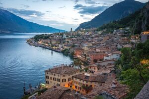
Limone sul Garda is a charming village on Lake Garda, in the province of Brescia (Lombardy), famous for its fragrant and rich lemon houses, excellent virgin olive oil and the longevity of its inhabitants. Narrow alleys, staircases, spectacular views and a picturesque harbor have made Limone sul Garda one of the most popular tourist destinations on the lake.
The historic center is full of ups and downs, alleys, staircases, paved streets, open spaces and terraces that offer wonderful views, colorful houses decorated with flowers and plants, craft shops. The colorful marina is a real charm!
Limone sul Garda, in my opinion, is perhaps the most beautiful town on Lake Garda, thanks to the mountains that surround it. It is surrounded by lemon groves. Limona has a picturesque historical center and a boardwalk on the shore of the lake, we really enjoyed walking along the alleys and the boardwalk, which is not long but the view is breathtaking, we really liked the ice cream parlors and restaurants.
My advice? Enter the historic center and start wandering, you will discover magical corners, Limon is also a fun town to shop in, there are many charming shops, fine ice cream parlors, pizzerias and restaurants, it is recommended to spend time there or in Riba del Garda in the evening, (in Riba del Garda there are performances by artists in the historic center, singers and musicians).
In the city center of Limone, in Piazza Garibaldi (Piazza Garibaldi), are the 17th-century Casa della Finanza palace with a covered terrace made of dark stone and the 18th-century Palazzo Gaffardi.
It is a special pleasure to walk through paved alleys decorated with flowering bougainvillea.
The ancient alley Via Fontana leads to the church of San Benedetto, which dates back to the 10th century and was rebuilt in 1691. If you walk from there you will reach the church of San Rocco hidden in the village alleys at the top of a flight of stairs. Decorated with frescoes from the 16th century.
If you want to relax, go for a walk in the park of Villa Boji, seat of the municipality, which houses a lemon house and several species of citrus and exotic plants. The park of Villa Boogie is open every day from 9:00 a.m. to 20:00 p.m.
Optional walking routes in the towns:
An optional walking route of about an hour in the town of Riba del Garda to the church: recommended***
When you will be in the historic center of the town of Riba del Garda, you will see that there is a church at a high altitude overlooking the town from above, it seems really impossible to reach it, this is the route that leads to it:
Walking route to St. Barbara's Chapel. This picturesque chapel was built by the miners during the construction of the hydroelectric power station. It reflects a wonderful view of the lake and of the entire town of Riva del Garda in the center of the city.
starting point
Riva del Garda, TN, Monte Oro Street - Bastione Street
End point
Riva del Garda in the city center, there is only one path from the chapel to the Riva.
through
Riva del Garda Bastiona, S.Barbara Hut, S.Barbara Church,
access to the starting point
By car: from the A22 highway choose the Rovereto Sud exit and follow the directions to Riva del Garda; In Riba del Garda look for a parking space near the town center, from the A4 highway choose the Brescia East exit if you are coming from the west or Peschiera if you are coming from the east and follow the directions to Riba del Garda.
Parking area
Riva del Garda (TN), Monte Oro Street
Description of the route
The chapel of Santa Barbara is visible from the town of Riba del Garda, on the mountain. The church was built in 1925.
The starting point of the trail is Monte Oro street in Riba del Garda, towards Bastione which can be easily reached in 15-20 minutes walking along a paved road. Here the path begins to go up to path 404, you can reach the chapel in about an hour. There are several panoramic points of the town, the lake and the surrounding mountains, and the view from the church is insane!
The return is on the same path back to Riva del Garda.
Bunker on Monte Brione Tour up to Monte Brione
There are many routes around Lake Garda that pass through bunker areas from the First and Second World War. Start on the lake shore of the beautiful town of Torbola at the Angelini Hotel. The path is easy and leads upwards. From the top you have an amazing view of all Turbula and Lake Garda.
The track lies between Torbola and the town of Riba del Garda, with a lovely view.
Total route length: 6.1 kilometers
Required time: about two hours.
Monte Bestone- an optional walking route about an hour and a half walk
The starting point to approach Monte Baston is from the town of Limone del Garda, located on the western shore of Lago di Garda.
– From the A4 Milano-Venezia highway, exit at Brescia Est, reach Salò and take Gardesana Occidentale to Limone.
– From the A22 Autobrennero Rovereto Sud exit, arrive at Riva del Garda and take Gardesana Occidentale to Limon.
When you come from Riva del Garda you will drive along the western Gardesana road in a southerly direction. Once you get to Limona sul Garda, just after the city center, find the right fork for Termosina. The road reaches the small villages of Eustatio and Voltino. For the last village on the right you will see the signs for "Pineta Campi – Le Balze". You can continue, even for a while, with the car going as high as possible until you pass the village of "Le Balze".
A walking route to Monte Baston starts from the parking site at the Hotel La Bellaza in Valtino (Tremosine sul Garda), follow the walking route 211. During the tour, you will have an amazing view of Lake Garda all along the way. It won't be long before you see the summit of Monte Baston. The whole tour lasts about an hour and a half, offers great views.
The total length of the route: 4.7 kilometers - about an hour and a half
After visiting Limone sul Garda visit Lake Tano - circle the lake for an hour. The lake is located half an hour from Limon Sol Garda. (the explanation appears the day before)
Or a visit to Verona Falls - only 17 minutes drive from Limon sul Garda
In my opinion, the lake is more beautiful, a special color, a pastoral and nice place to surround the lake and even dip in it, but if you are fed up with lakes, choose the waterfalls.
Visit the stunning Cascata del Varone waterfall, where the waters of Lake Tano flow into a narrow gorge
Verona Falls
שעות פתיחה:
09:00-19:00
Address: Località Le Foci, 3, 38060 Tenno TN, Italy
The visit to the Varone Falls includes several observation points. The first view can be seen from below, through the lower cave: from here you can watch the waterfall in its final stage. The second observation point, on the other hand, is located 40 meters higher, in the upper cave, from where you can admire the Varone waterfall in the middle of its fall.
The cave and the waterfall are located inside a private natural park, you can go up to the paths, the bridges, the railings and the winding staircase, and watch this impressive natural spectacle.
Note additional optional walking routes in Lake Garda:
Tour to the waterfalls Cascate di canai - Cascata Piovere
Tour to Cascata Piovere, the word cascata means waterfall in Italian. Total route length: 4.9 kilometers
Required time: an hour and a half.
The circular tour starts from the village of Tignale Aer. After parking, follow the signs towards the falls and take trail no. 265: The path begins to descend inside the grove where it becomes rocky at times and is well equipped with fixed ropes to help you. You will reach the Tignale waterfall and a deep and fascinating natural pool. This place deserves a small stop. Continue on the path that begins to climb with a few steps and pass the stream. Reach the top of trail 265 and turn right on route 251 in the direction of Aer with panoramic points on the river. The path finally becomes asphalt again and you go down to the parking area in Aer, the starting point of the route. This tour is not difficult but it is better to wear trekking shoes and pay attention to certain rocky points especially in the presence of wet ground.
Additional explanation for the route:
After parking the car near the Arcobaleno Park, walk towards the center of Gardola along Via Panoramica and via Badiale, then following the main road.
After a few tens of meters enter via Chiesa, marked 266. Go down to the village of Oldesio. A few tens of meters after the church, next to which is the fountain area, you will find on the right the sign for Air.
The trail takes us to cross trail marker 265 in just over a kilometer. Once in Aer, we go uphill towards the Church of Saints Bernardo Valentino. A few meters further, to the left, take path 265, in correspondence with via Marsala, at the end of which you pass under the face. The itinerary continues on a dirt road: you enter the valleys that host the spectacular waterfalls and continue following the signs for trail 251 Vione. You will reach the latter, after going up steep stairs, turn right towards Aer. After about a kilometer and a half you will find yourself crossing via Panoramica, the road leading back to Gardola.
Monte Cocca Monte Cocca
Monte Coca is a route that offers you an amazing view of Lake Ledro. Start at Pieve di Ledro, walk through the village and turn onto Via Rabaglia. Follow the signs for the path SAT 454 - towards Bocca di Monte Cocca. The views from the top are breathtaking.
The route leading up to the top of Monte Coca offers a beautiful view of Lake Ledro and the villages on the valley floor.
Total route length: 8.5 kilometers
Route length: 4:00 hours
Monte Pizzocolo
Monte Pizzocolo is the highest mountain in the southwestern part of Lake Garda at a height of 1581 meters, also called Monte Sera ("Sera" ohne Akzent auf dem A). The normal path leads along Malga Valle. The route is quite long but easy to follow.
Route length: 4:30 hours
Monte Pizzocolo overlooks Toscolano Maderno and is clearly visible from the eastern shore of Lake Garda, accessible from Toscolano Maderno. You will arrive at the parking lot at Il Palazzo, then walk along the path. Round trip in less than 5 hours, including a detour to reach the Pirlo Refuge.
It is a moderately challenging route, taking an average of 5 hours and 14 minutes. Pay attention, the route is quite isolated, it is unlikely that you will encounter many people.
Madonna di Montecastello – Monte Castello
This trip takes you to Madonna di Montecastello - a pilgrimage church. The trip is easy, takes no more than 20 minutes and leads from the monastery to the top of Monte Castello. From there, there is a great view including the summit cross. This cross is also located on an old bunker. At the top there is an observation deck. You can take the same road back or follow trail 266 further down the road. You will reach Prabione and follow Via Campogrande. Eventually, you'll pass the Parco Alto Garda Bresciano Museum.
Total route length: 4.7 kilometers
The route length: 2:20 hours.
Monte Tomeabrù
The hike up to Monte Tomeabrù is very rich in views before reaching the ruins, the path will lead you towards the cross of Carèt and the summit of Monte Tomeabrù. In spring and summer you will find many flowers in all the meadows.
Total route length: 9.8 kilometers
Route length: 4:30 hours
Difficulty level: medium.
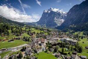
Day 5: 4.8 Dolomites Arrival to the town of Ortisei
A journey of about one hour and 45 minutes or two hours, depending on the place of accommodation - try not to take breaks, but do enjoy the views on the way and leave early to arrive as early as possible - you have a day full of activities today
Arrival in the town of ORTISEI
Ortisei is a picturesque town located in South Tyrol in the Gardena Valley - Val Gardena
The cobbled pedestrian area between St. Anthony's Square and the central church embodies the main shopping street of the valley and is surrounded by picturesque and colorful cafes, restaurants and hotels. The town is surrounded by green mountains, gondolas and cable cars that can quickly take you from Ortisei to Alpe di Siusi or Les Sacada, where you will encounter spectacular views.
I suggest leaving the trip in the picturesque and beautiful town and strolling through it in the afternoon to have time to enjoy the cable cars in the town
For all cable cars in the area
Seceda, is the most popular peak in the town
The easiest and fastest way to get to Seceda Ortisei-Furnes-Seceda from Ortisei in Val Gardena. From the mountain station of the cable car, it is only a 10-minute walk to the viewpoint on the summit. From here you can continue along the ridge line of Seceda towards the Udal peaks.
. It takes about 5 minutes to walk from the center of Ortisei to the Seceda cable car, via the La Corte pedestrian connection.
From Plaza Antonio, look for a sign to "Seceda". Walk down the small street between Sparkasse Ortisei Bank and the Calzature Rabanser Di Senoner Emilia shoe store.
Take the indoor "La Curta" escalator to the top. After the escalators, locate the pedestrian tunnel straight ahead with a conveyor path, escalators. When you reach the end of the tunnel, you have arrived at the Seceda cable car valley station.
Address of the cable car:
Seceda Cableways
Via Val d'Anna 2
There is a paid parking lot directly at the Emek station, with a maximum capacity of 250 spaces.
Parking costs €8 per day.
Enjoy watching the Sacada.
Another option is a walking route, but for the purpose of the route you get off the cable car at Seceda / Puez Odle
To get to this route you have to take another cable car called Col Raiser to Col Raiser Almhotel. The trip starts from there. Follow the signs to Fermede and Seceda. As you walk, you can see Massif Ssolungo on your left as well as Sela.
the route
Keep walking until you reach Fermeda Rifugio. From there the hike will get steeper as you go up Mount Seceda. Following the well-marked path up, you'll walk past nice cottages and pastures.
Walk along the path that passes by Baita Sofie, you will pass Ristorante Seceda, you will go to the top. From here you can also go down to Ortisei by cable car.
From the summit you can see Sassolungo and Passo Sella and below the Alpe di Siusi. Then, continuing clockwise: Catinaccio and Siliar, the Cartine Alps, the Austrian Alps, the Piccolo and Grande Seceda, and the massive Sass Rigais.
Continue on the path, which from then on descends and enter the Parco Naturale Puez-Odle. Continue on the path as it moves towards Pieralongia, following the marked path. During the walk you will see the Poise, Sella and Ssolungo mountains. Some small alpine lakes.
Once you reach Rifugio Pieralongia, keep going straight for a while. Then, follow the signs that will lead you back to the Col Raiser cable car, which will take you to your car.
You can rest at Rifugio Fermeda for a light lunch.
Another recommended option: get on the Alpe de Sioux cable car from Ortizi-
This is the cable car to take from Ortisei: Link Link 2
It is not for nothing that Alpe di Siusi is one of the most popular holiday destinations in South Tyrol in the summer. The largest mountain pasture in Europe is only 20 kilometers from Bolzano and charms visitors with an alpine landscape with the rugged peaks of the Dolomites in the background. A mountain landscape straight out of fairy tales. Since the Seiser Alm in South Tyrol is already at an altitude of 1,700 - 2,300 meters, it is the perfect starting point for leisurely walks or sports trips. Large areas of the landscape are defined as a nature park.
The square kilometers of Alpe di Siusi are designated as a protected biotope in South Tyrol and there are only a few hotels and roads on the level. Most of the accommodations are located directly in Kompatesh, the starting point for excursions. Below the Alpe di Siusi are the villages of Seiss am Schleren, Kastelroth and Ortisei in Gruden. These towns are also very good starting points for a holiday in the Alpe di Siusi in South Tyrol.
May to September is the perfect time for a summer vacation to hike the Seiser Alm in South Tyrol. From May to July the alpine meadows are especially green. The nice thing about summer in the Alpe di Siusi: even if the temperatures in South Tyrol climb to over 30 degrees, it stays pleasantly cool in the Alpe di Siusi because of the altitude. Alpe di Siusi counts about 300 sunny days every year - but be sure to check the weather forecast before you go for a walk.
There are different ways to reach the high level of Alpe di Siusi. It is not possible to simply travel by car at any time, because access to the private road is limited and closed daily from 9 am to 17 pm. The only exception: if you have booked a hotel in Alpe di Siusi, you can board or disembark at any time on the day of arrival and departure.
Another cable car not from Ortisei but from the town itself Alpe di Siusi: travels from Seis am Schlern to Compatsch, daily 8:00 - 18:00/19:00.
מה לעשות?
Note that in Alpe da Siusa, on the level itself, after you have ascended the cable car from Ortizi, there are views of meadows and spaces, horses, hiking trails, and other cable cars that go up for additional observations. Take one of the walking or cycling routes or take the cable cars, or just enjoy the views and views before descending back to the town of Ortisei.
Hiking trails in the Alpe de Sioux
Puflatsch loop on Alpe di Siusi
Duration: 3:00 hours
Length: 7.9 km
Height difference: 329 m
Difficulty: Easy
Starting point and ending point: Excursion parking lot or Compatash mountain station
If you are looking for an easy but very beautiful hike in Alpe di Siusi, the recommendation is the Puflatsch loop. Here you can experience the whole of South Tyrol in rapid succession, green alpine meadows and far-reaching views of the Siliar, Sassolungo or the Puez group, which represent the Dolomites. The panorama is overwhelming and will make you take a lot of pictures. There are many places to stop for refreshment along the way, such as the Poplatsch hut or the Arnica hut. You have one of the most beautiful views in Wetterkreuz and Gollerspitz. Link
Trip Hofer Alpl
Hiking from the Völser Weiher to Tuffalm and the Hofer Alpl at the foot of the Siliar
Völser Weiher is one of the cleanest bathing lakes in Italy
This beautiful circular walk in the Schlern-Catinaccio nature park leads past two alpine huts in Tuffalm and Hofer Alpl.
Directions TUFFALM AND HOFER ALPL
The trip to Tuffalm and the Hofer Alpl starts at the spacious hiking park near the Völser Weiher.
Here you follow path No. 1 towards Tuffalm, which first leads past the idyllic Völser Weiher and the slightly smaller Huber Weiher.
After walking for a few minutes you will come to a fork in the path: the wider and more relaxed forest path branches off to the left, and the slightly steeper but shorter forest path branches off to the right. Both lead to the family-friendly Tuffalm, which invites you to enjoy a break in the middle of a spacious sunbathing lawn at the foot of the Siliar.
A little below Palam, follow path No. 1, from which forest path No. 1A branches a little later to the right. It leads straight to the popular Hofer Alpl, surrounded by forest and meadows and has a sunny panoramic terrace.
From the inviting alpine cabin, path No. 3 leads to a peaceful forest, which repeatedly reveals views of the impressive Amerwand, the mountains opposite, Wells and its surroundings.
Following the paths numbered 8A, 8 and 2 one after the other, you finally reach the Völser Weiher and thus return to the starting point.
Defined walking times TUFFALM AND HOFER ALPL
Parking - Tuffalm: 50 minutes
Hofer Alpl parking lot: 1:20 hours
Hofer Alpl Hofer Alpl - parking lot: 1 hour
Not far from the picturesque Völser Weiher lies the so-called "Hexenstein", a moss-covered rock that probably broke away from the Siliar thousands of years ago.
travel information
Time: 03:00 hours
Length: 9.3 km
Height difference: 425 m
Minimum height: 967 m
Maximum height: 1388 m
Electric bike rental in Alpe de Sioux
In the Dolomites and El Gardena there are various bike rental stations where you can easily rent an electric bike for the day or your entire vacation. You can go on one of the guided tours.
In the villages of Val Gardena, in cabins and restaurants you can find charging stations for electric bikes.
Evening entertainment
Have dinner at a restaurant in Ortisei - the restaurants are the best, there is no point in leaving the town in the evening, it is more bustling than nearby towns
Maurice Keller - Restaurant - Pizzeria
Italian restaurant
Service options: eat on site · self collection · no deliveries
Address: Strada Rezia, 32, 39046 Ortisei BZ, Italy
SNETON: Restaurant in St. Ulrich
Bar restaurant
Address: Streda Sneton, 26, 39046 Ortisei BZ, Italy
Restaurant Pizzeria Lamm
Huge pizzas
Address: Strada Digon, 6, 39046 Ortisei BZ, Italy
Restaurant Pizzeria Terrazza
Address: Via, Streda Sneton, 7, 39046 Ortisei BZ, Italy
Recommended, I really enjoyed the food
Cascade Ristorante Pizzeria Bar
Pizzeria
Address: Strada Promenade, 1, 39046 Ortisei BZ, Italy
Recommended - I really enjoyed the food
Another option: about an hour from Ortisei - to relax in the baths
QC terme Dolomiti
It's a crazy and huge spa complex that spans three floors and as big as it is, it's also well-maintained and meticulous and clean. The spa is open until 22:00 at night.
Note: If you don't feel like taking the cable cars today, or if there are clouds or precipitation and there is no point in going up the cable car, you can always visit one of these lakes in the Dolomites:
lago di tovel-Lake Tovel
The lake is surrounded by forests and peaks of the Brenta Dolomites. It is characterized by shades of green and blue.
Tubal Lake is the largest of the natural lakes in Tarantino and is one of the jewels of the Adamello Brenta Natural Park.
When you visit Tubal Lake, be sure to walk the simple loop following the perimeter of the lake for a wonderful view. The path is flat and takes about an hour. Several hiking trails leave the lake. You can also stop by the Casa del Parco Lago Rosso, a museum dedicated to Adamello-Brenta Park and its beloved resident symbol of the park, the brown bear.
Tubal Lake is one of the most impressive and well-known places in Tarantino. You can walk around the lake and spend the day on its beaches.
How to get
From here follow the signs and take the SP14 of Val di Tovel which ends at the parking lot at the foot of the lake.
Another way to get there - "Sentiero delle Glare" it starts from Loc. Capriolo, and climbs into the forest until he reaches the lake.
Another recommended lake is the famous Kartsa lake
Although much smaller, its color is very special and it is surrounded by jagged mountains - it is Lago di Carezza, you can circle it in about an hour.
Further along the route I have put another famous lake for you, Lake Bryce - we will meet it later.
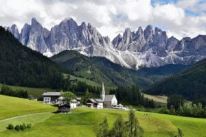
Day 6: 5.8 Dolomites - Passing the Sella Mountains and the Sass Perduy summit - not to be missed
A very beautiful day ahead of you - the peak of the Dolomites and must-see places - do not deviate from the plan on this day and leave this day for a clear day with good visibility without precipitation, that is, change between days if there is rain
Passo Sella Dolomites Sella Pass
Passo Sella is a high mountain pass 2.246 meters (7,368 ft) above sea level, located on the border of the provinces of Trento and Bolzano, in northern Italy.
The winding road to the summit, also known as Sellajoch, is paved, with sharp bends. It is called Strada Statale 242 road. The pass connects the Val Gherdëina in South Tyrol and Canazei in the Fascia Valley in Tarantino.
Sella Pass Located in the saddle that separates the Sassolungo and Sella mountain groups, Passo Sella connects Valle di Fassa with Val Gardena in the Tarantino Alto Adige region.
Passo Sella is one of the most famous passes in the Italian Dolomites, see an unforgettable view of the Sassolungo mountain group, at an altitude of 3,179 meters above the roof.
Sella Pass, is one of the most iconic roads in the Dolomites and the drive on it is one of the most beautiful views not only in Italy, but in the world, just enjoy the views on this day.
Driving on the scenic Pas Sala road. Purdue pass together with Sella pass, Val Gardena, and Campolongo pass forms part of Sella circuit.
The road is located between Sassolungo and the Sella Group, Sella Pass connects Val di Passa and Val Gardena along main road No. 12 km. 242, connecting the mountain pass to Canazie. One of the most famous passes of the Dolomites, near the Mesules barrier. The view is to Passed Sassolungo, at an altitude of 3,181 meters.
The Sella Pass is one of the most classic passes in the Dolomites. There are several options on how to get to the pass. You can reach it from a nearby pass on the Sela ring - Jëuf de Frea/Grödner Joch/Passo Gardena from the north or Passo Purduei (2239 m) from the south.
What to do in Paso Sala?
It's a scenic road with breathtaking views, you drive it and stop every now and then at bays, see the view, until you get right to an inn and a souvenir shop with a big sign, where you also stop for views. I made the transition several times and never got enough of the views.
The summit Sass Pordoi - highly recommended, don't give up
It is recommended to check the weather in advance, ask the hotel if the visibility is good and there are no clouds before reaching the summit
After traveling on the scenic Passo Sella road, it is highly recommended to take the most beautiful cable car in the Val Gardena area.
Address of the cable car: Passo Pordoi, 38032 Canazei TN
Sas Purdue is a 2,950 m high, plateau-like rock peak, accessible by cable car from the Paso Purdue ridge.
The Sass Pordoi cable car in the Sella group goes up in 4 minutes. One of the most important peaks of the Sella group. On the plateau there is a platform, a sort of panoramic balcony for observation towards the Marmolada and Langkopel groups. and a restaurant. The view from the balcony is truly breathtaking.
To the west are the Alpe di Siusi and Catincio, to the south the Val di Passa valley and the Marmolada glacier, with 3,343 m above the highest mountain of the Dolomites and to the east the Sella Group and its highest peak, Piz Bui.
Enjoy a 360 degree view of the entire alpine area.
After disembarking from Sass Porduy if you haven't had lunch yet, drive 11 minutes to the town of Canzey for lunch.
If there is time left, also make an observation from the Sasso Longo summit - note that this cable car is not suitable for people with disabilities because it has to be avoided on the way up and down - at the same time it is fun and safe.
Langkofel
The Spallone Sassolungo The southeastern peak of the mountain, it covers half of the entire Sassolungo group.
You go up in a special cable car with one compartment, maybe two people enter it while standing, you have to jump on it to go up and stay on the way down.
Telecabine Gondelbahn Forcella del Sassolungo
Address: Strada statale N.242, Località Passo Sella, 39048 Selva di Val Gardena BZ, Italy
There is an amazing lookout, stunning views of the Sella Group, Mount Marmolada, the highest peak of the Dolomites, and Alpe di Siusi, Europe's highest high Alpe.
At the end of the day return for dinner and overnight in Ortisei.
After the cable car is optional: if it's not evening yet and you have time:
Gardena Pass ** is recommended about half an hour from the town of Ortisei
Another recommended scenic road, the Gardena Pass is located in the Dolomites, between the Val Gardena Valley and the Bedia Valley.
The high road No. 2 from Bressanone to Feltre crosses the pass. Breathtaking views all along the road of the peaks.
I really liked the views, but if there is time for one mountain pass, choose Sala.
Day 7: 6.8 Dolomites Lagazuoi peak or Marmolada peak or an easy and stunning walking route the Catinaccio cable car from Vigo di Fassa, you can combine two cable cars, as time allows
Option 1: about an hour's drive from the town of Ortisei
Cable Car Lagazuoi- highly recommended, breathtaking view
At:
Passo Falzarego, 32043 Cortina d'Ampezzo BL
to the top
Lagazuoi is reached by the cable car that opens at nine in the morning, it is advisable to arrive early.
The Lagazuoi cable car takes you up from Paso Palzargo (2105 m) to a height of 2732 m, just below the 2778 m Lagazuoi summit. The cable car goes up in less than 3 minutes
From the top there is a breathtaking view of the Dolomites, from the impressive views we saw, very very beautiful, I highly recommend it. You can also visit the open-air museum of the World War, and the fair center Lagazuoi EXPO Dolomiti.
Walking route (optional):
A hike from Rifugio Lagazuoi and back to Passo Falzarego is a wonderful trip. There are views from a mountain top, a gondola ride, historical ruins, a restaurant in a cabin with some of the best strudel in the entire world, and the possibility of going on a fun trek.
Description of the route from Lagazuoi to Passo Falzarego
Take the Falzarego-Lagazuoi gondola up the mountain, you'll see amazing views even before starting the trip.
The trip from Rifugio Lagazuoi.
From the cable car we ascended a clear path leading to the northwest from the left side of the refugio. Sienteri Italia it should take along the ridge of Lagazuoi. You will have amazing views all the way here. There is one section near the beginning that does require careful balance, so be careful.
After enjoying the views, head back to the refugio and treat yourself to one of the best strudels in the area.
After that, you will pass the refugio and continue east. This path should take you to the forts and tunnels of the First World War. Then continue on the clear path that descends towards the valley.
Go down the mountain using one of the ski tracks. Do not go down the path under the gondola, it is narrow and not easy. When you descend you will go towards the saddle of Lagazuoi, past Forcella Travenanzes. From there look for trail number 401-402. This path will lead you down a slope and back to the start of the gondola. The views of the peaks are amazing. The path leads back to the gondola.
The route is considered moderate, but there are some challenging, hands-on, exposed trails that descend over Lagazuoi Peak as well as below the cable car. Always follow the easier route that follows the ski route.
Option 2: about an hour and ten minutes from the town of Ortisei
The peak of the Marmolada
The Marmolada cable cars - 3 cable cars up to the highest peak
The ascent includes three cable cars leading from Malacca Ciapella to the top of Punta Rocca. The first cable car that starts from Malga Ciapèla from 1450 meters reaches Coston d'Antremogja (2350 m). The second from Costo d'Antramoja (2350 m) reaches Cerrota (2950 m) to continue with the third to the top of Punta Rocca (3265 m), in front of Punta Peña which at 3343 m is the highest peak in the Dolomites.
Only 12 minutes away from Malacca Ciapella, along the Belonese side of the Queen of the Dolomites, you can comfortably reach the top of the mountain, where you can admire the spectacular glacier and a 360-degree view.
Viel del Pan route
Marmolada-amazing route to the lake
A route that connects Passo Fedaia with Passo Pordoi, and offers amazing views of the Dolomites, especially of Marmolada.
From Via Pareda take the cable car to Pecula and from there take the cable car to Col dei Rossi – Bellavista. The trail (route #601) starts from there.
Once you get off the cable car, you'll see a view of Solongo, Marmolada, Sella, Purdue and Catinaccio.
Follow the sign for Viel del Pan. The trail is quite flat, with some slight ups and downs. You walk away from the cable car, initially towards Rifugio Belvedere di Canazei. From here we continue on the path to Rifugio Fredarola, which is about 20 minutes from the top of the cable car. The views in all directions are stunning!
Continue along the path and reach another Rifugio, this time it's Rifugio Viel del Pan. As you continue on the path you will begin to see your destination, Lago di Pedaya. Continue until you see a path with wooden and dirt steps going down. Descend until you reach Pedaya Lake, this amazing lake at the base of Marmolada is amazing.
If you don't want to go back, there are buses to Canazei, although sometimes the wait can be up to two hours. Check the schedule and if you have a wait, come in and refresh yourself at the Refugio Castiglioni Marmolada cabin.
Option 3: a stunning walking route about an hour's drive from Ortisei:
If you are looking for an easy walking route in the Dolomites, here is a mostly easy walking route, you can return from it at any stage and the view is one of the most beautiful I have seen in the Dolomites. I really liked this route.
See a video of the route and the exact name of the route HERE
The Catinaccio cable car from Vigo di Fassa
Vigo di Fassa
With a stunning view of the Sella and Marmolada mountains, Vigo di Passa is the ideal starting point for amazing hikes in the legendary Dolomites. From relaxing walks through the forest to long hiking trails.
A cable car takes you from the center of the village to the heights of Mount Ciampini (2,000 m above sea level), from where you can go on many excursions.
The route is mostly easy and flat without any climbs, if it starts to get difficult, after an hour, an hour and a half you can simply go back the same way you came:
Dal Ciampedie al Rifugio Gardeccia
The most beautiful route in the Dolomites, in my opinion, is 14 km, (you don't have to go the whole way, it's a very easy route, later it becomes moderate, you can return at any stage).
On this trip you will climb Vajolet and Re Alberto in the Dolomites of Val di Fassa. We start from Vigo di Fassa.
Parking area
Leave the car in the paid parking lot not far from the Catinaccio ski lift. After a short walk through the streets of the town of Vigo di Fassa you will reach the escalators that will very conveniently lead to the ticket office of the cable car.
The route to Vajolet starts from Ciampedie Refuge and can be reached by cable car:
The Catinaccio cable car from Vigo di Fassa
Take the Catinaccio cable car from Vigo di Fassa which in a few minutes leads to Ciampedie at an altitude of 1998 meters above sea level. Take the path to the right and go down towards the grove and from there continue on foot for about 40 minutes along path 540. You will reach Catinaccio and shortly after Gardeccia.
The first part of the trip is easy and fairly flat, where you will also meet families with children who usually stop at the Gardeccia Refuge, at an altitude of 1,950 meters above sea level.
** Even if you don't do the whole route, I strongly recommend that you go at least as far as the Gardeccia Refuge. That this is a cabin where you can also stop for coffee, cake and toilets.
You can stay there and return to the cable car or continue on the following route:
From the Gardaccia basin begins the wide and well-marked trail 546, which leads in a steady ascent to the foot of the Catinaccio in about an hour. The last part of the climb that leads to the Vajolet Refuge and the small Preuss Refuge is quite difficult, it leads to the heart of the Catinaccio, at an altitude of 2,243 meters : Needless to say, the view is spectacular wherever you look.
Continue following the signs towards Vajolet and Preuss. To get there you go up a wide dirt road, it has a moderate slope.
Continue up the main path to Paso Principe, from where you start the via ferrata of Catinaccio d'Antermoia. Take the first path on the left, which climbs over the rocks towards the saddle.
Going up along the trail after about an hour and a half of climbing, you finally see the roof of Re Alberto Refuge and then Vajolet on the right.
If you don't feel like continuing, you can still stop at Vajolet Refuge: the view is spectacular even up to this point near the cabin.
The path is not circular, so to go back to the cable car you came from, just follow the path back.
So far the easy route
Explanation of other ways to get to the Vajolet trek starts from Ciampedie Refuge and can be reached in two ways:
with the Catinaccio cable car from Vigo di Fassa
With the chairlifts Vajolet 1 + Vajolet 2 + Ciampedie / Pra Martin from Pera di Fassa
Given the almost identical cost (19 euros round trip)
We took the Catinaccio cable car from Vigo di Fassa which in a few minutes leads to Ciampedie and from there we continued on foot for about 40 minutes along trail 540.
Gardeccia can be reached from Pera di Fassa with the chairlift Pian Pecei 2 Tronchi (Vajolet 1+ Vajolet 2) to which you can add about 30 minutes on foot along the path in the forest.
The more difficult part of the route is optional only, not mandatory
The last section of the route is demanding, after Vajolet, go left on path 542 which climbs along the basin between Punta Emma and the eastern tower and which is classified as EE - Expert Hikers due to the presence of sections equipped with metal ropes at the most challenging points.
If you are not too tired, you can make a last effort and climb in about half an hour to Paso Santner and see Re Alberto I from above.
Going back on the same path.
From Rifugio Fronza alle Coronelle there are two options:
Go up to Passo delle Coronelle following path 550, cross the hill along the scree and take the detour to path 541 towards Vajolet Refuge where you follow path 542 to Re Alberto I Refuge
Take the via ferrata of the Santner Pass to reach the pass of the same name from which you quickly descend to the Re Alberto I Refuge.\
Day 8: 7.8 drive an hour and a half from Ortisei to another stunning area in the Dolomites, Cortina de Ampazzo:
Drive an hour and a half from Ortisei to the Cinque Terre peak or drive an hour and a half to Bryce Lake and from there another hour to the famous Terra Chima peak.
At the end of the day, take a walk in the town of Cortina di Ampazzo and dine at a recommended restaurant.
CINQUE TORRI
Peak in the area of the town of Cortina de Ampazzo - about an hour and a half from the accommodation in Ortisei
These are five mountains (hence the name Cinque Terre) that reach a height of between 2,200 and 2,360 meters, and are located at the base of the Averau and Nuvolau mountains, in a prominent position, easily visible from the Ampezzo valley. They can be seen from the center of Cortina and many parts of the town, and at first glance they appear to be five towers.
From Cortina, take the Strada Statale (main road) towards the Falzarego Pass and turn onto the steep asphalt road towards the Rifugio Cinque Torri mountain hut. During peak season the road is closed to vehicle traffic, but you can take the shuttle service, or walk up in about an hour. Alternatively, leave your car in the parking lot on the Island of the Dons and take the chair lift to the Rifugio Scoiattoli mountain hut, from where you can reach it in a few minutes.
From the parking lot, take the Cinque Torri chairlift to Rifugio Scoiattoli, from where you can enjoy a stunning view of the Cinque Torri mountains.
A few hundred meters from the lodge you will find the Cinque Terre Open Air Museum: there are the trenches and the perfectly reconstructed places of the Great War.
walking path
Distance: 5 km / 3 miles
Walking time: 2-3 hours
Walking difficulty: easy
Start at rifugio Col Gallina, near passo Falzarego, along trail #440. There is plenty of parking. On the opposite side you can find a small restaurant "De Strubel". If you have extra time, you can make a slight detour of the beautiful Lago Limids and add about 45 minutes to the trek.
From the rifugio Gallina the path winds along the Río Palsargo but before long breaks off from the stream and begins to climb.
The goal you can see from quite a distance is rifugio Scoiatolli, a beautiful mountain hut located only a few hundred meters from the Cinque Terre. The route is well marked and encompasses only 200 m of elevation gain.
Once you arrive on the hour-long road, you will see a large number of trails going in all directions towards the Cinque Terre. choose one The whole area was used extensively, just like the tunnels in Monte Lagazoui, during the First World War and many trenches and excavations still remain in the area.
The view towards Passo Falzarego from Cinque Torri There are plenty of main paths that lead to Cinque Torri, spend an hour taking in the views while lounging on one of the many lounge chairs belonging to Rifugio Scoiatolli.
Part of the much longer Alta Via 1 (142 km), this short hike is an excellent introduction to the fascinating history of the Italian Dolomites.
Another option: drive from Ortizi an hour and a half to Lake Bryce, the most famous alpine lake in the Dolomites
Lago di Braies- Lake Braies
You can circle the lake or rent a rowing boat. Around the hotel clockwise or counter-clockwise, from the Lake Braies Hotel, follow a wide path along the lakeshore, past the small chapel to the turnoff to Grünwaldtal. The road so far is also suitable for carts. Now the path narrows a little and leads on steps adjacent to the cliff above the eastern shore of the lake to the starting point at the Lake Braies Hotel, which should be reached after a walk of about 1.5 hours.
Lago di Braies P3 Parking Lot
This is the largest and closest parking lot to the lake. It's a gated, ticket-operated parking lot. You will grab a ticket upon entry and pay for parking before exiting. The first 15 minutes are free. If you need to pay by credit card, you can pay inside the hotel. If you lose your card, it's 50 euros to shop here.
Lago di Breeze parking lot P2 –
The P2 parking lot is also very close to the parking lot. This parking lot is privately managed. Someone will personally collect the parking fees. If you plan to make a longer trip (over 3 hours), park here.
The cost is 6 euros per day for cars
Lago di Breeze parking lot P1 meter
Parking lot P1 is paid and smaller than P2 and P3. There is only a daily rate. The ticket machine is next to the kiosk. You can pay with coins or with a card. Bring euro coins in case the machine doesn't accept your card.
Only if you go to Bryce Lake early in the morning, continue from there with a drive of almost an hour to the famous peak in Terra Cima Park - highly recommended, after visiting Terra Cima drive 37 minutes to the town of Cortina di Ampazzo, eat at a restaurant and then you will have a XNUMX hour drive to the place the accommodation
Terra Chima
Tre Cime di Lavaredo Loop
This is the most famous peak in Cortina d'Ampezzo and the most famous route in the Dolomites
It is recommended to come even if you don't do the famous circular route, the view is stunning.
TRE CIME DI LAVAREDO trip
The 10 – 11 km Tre Cime di Lavaredo loop is an easy/moderate hike that should take about 3-4 hours.
The route is well marked and is clearly shown on Google Maps and Maps.me.
Starting at Rifugio Aurenzo, follow the wide gravel path (101) leading east towards the Cappella degli Alpini, a picturesque Alpine church, before continuing to the first of many picturesque mountains, Rifugio Lavaredo.
On the left rise above the three peaks (hence the name Terra Chima Three Peaks)
At the hut you can stop for a drink, continue straight towards Forcella Lavaredo, one of the best viewpoints in the entire Tre Cime di Lavaredo loop. From Rifugio Lavaredo, turn left and follow trail 101 up towards the viewpoint.
The jagged peaks of Labrador tower impressively. It is recommended to stop here for a moment or two and observe the views of the valley and towards Rifugio Locatelli (also known as Drei Zinnen Hutte).
From Porcella to Varado, the trip winds towards the most iconic rifugio in the Dolomites, Rifugio Locatelli / Drei Zinnen Hutte.
There are several trails that can be taken from Porcella to Vardo towards Rifugio Locatelli. You can choose to follow the wider and more comfortable lower trail (continuation of trail 101), which descends into the valley below the three peaks, or the upper trail, which is carved into the rock falls of Croda Passporto and Monte Paterno, and provides a more exciting experience.
Your hiking skills/experience will determine which route you choose, but if you are steady on your feet and up for a bit of a challenge, the upper trail will give you a more exciting experience and better views.
Once you've arrived at Rifugio Locatelli, stop for a break on the sun terrace to enjoy food and a view of the impressive Tre Cime peaks. Walk around Rifugio Locatelli a bit.
There are a number of WWXNUMX bunkers and tunnels and some interesting viewpoints on the Three Peaks. The easy hike down to the Laghi dei Piani, the two picturesque lakes just below Rifugio, is worth the detour.
From Rifugio Locatelli, follow the trail (102) down into the valley ahead, stopping occasionally to soak up the three peaks, which tower impressively above.
This is where the hardest part of the Tre Cime di Lavaredo hike takes place. The trail follows a seriously steep incline back up the ravine, the incline eventually ending at a junction of many trails.
Join trail 105 towards Malga Langalm rifugio, crossing the flowing stream of Sorgenti del Rienza before reaching Malga Langalm.
If you haven't eaten at this point, stop here at Rifugio for a rest and a drink.
The last part of the hike Tre Cime di Lavaredo is fairly easy, following trail 105 at a slight incline around the three peaks towards the Forcella del Col de Mèdo viewpoint. From here you can see down to the Foster Valley, and also towards Lake Misurina (in Belluno district). It's a 10 minute walk to the parking lot and the end of the trip.
Cortina d'Ampezzo
After Terra Cima, it is recommended to take a walk in the evening in the charming nearby town of Cortina de Ampazzo,
I recommend the restaurant 5 Torri at Largo delle Poste, 13, 32043 Cortina d'Ampezzo BL
The town bustles with life in the evening, it's pleasant to walk around, see churches and there are many restaurants open in the evening, all restaurants are excellent.
Day 9: 8.8 Venice
Drive from Ortisei early in the morning towards Venice - leave very early the journey takes about three hours and twenty minutes (it is still better to do it in the morning on the last day than on the first day with landing in the evening in the dark when you are tired after a flight) drive with the car and leave the luggage at the hotel, then return the car At the point closest to the city center of Venice, continue on foot, walk until the evening and settle in a hotel near the airport for an early morning flight.
The small city of Venice, attracts millions of tourists from all over the world, despite being very touristic, it has never lost the secret of its charm, no matter how many times you return to it in your life, thinking you have already seen everything, you will be deceived and each time you will find a hidden corner, you will get lost In the picturesque alleys of the city, you will miss a beat when you see a boat sailing on the river in front of the sunset and many more magical moments that are worth recording on your cameras. Strolling in Venice is a guaranteed pleasure, the canals invite you to cruise, the bridges, St. Mark's Square with its magnificent architecture that will leave you speechless, the bustling streets, the joy of the hospitable Italians.
The richness of the artistic, architectural and historical heritage of Venice makes it a city without a second. You cannot miss the Basilica of San Marco, which overlooks the square of the same name, the Doge's Palace, the Promenade on the Grand Canal, the Rialto Bridge, the Gallery of the Academy... around every corner there is a unique glimpse of rare beauty.
Start by visiting the Jewish quarter. It was the first ghetto in the world established in 1516, when the Venetian Republic confined the Jews to this area of the city. Today, a distinct Jewish population remains in the area, with synagogues, Jewish restaurants, bakeries and a museum.
What does a tour of the Jewish ghetto include?
The Jewish Museum and Synagogues - For details and tickets for the tour
Kia Ghetto Vecchio, the main street of the original Jewish quarter, is a narrow street, you will recognize it by the signs of kosher restaurants, today you will find the wonderful Avroico Museum, or the Jewish Museum of Venice, which is very worth visiting to understand the history and lifestyle of the Jews in Venice.
The museum of the community sheds light on the story of community life over the years - reviews the fascinating history of the Jews of Venice.
You can enter the museum from Campo del Ghetto Nuovo, the visit to the museum includes a tour of the Scole, as they used to call synagogues in Venice. In the Venice ghetto, today you will find five synagogues, all congregating in a small area near the Jewish Museum. You can take a guided tour of the synagogue from 1528 known as the Schola Tedesca, the Canton Schola 1531 and the Schola Italiana from 1575 through the Jewish Museum. The tours leave every hour.
Scola Levantina and Scola Spagnola are in the old ghetto. The rest are Scola Grande Tedesca, Scola Italiana, and Canton ("Corner") Scola are in the new area.
The museum's library is called "Alf", as the first letter of the Hebrew alphabet, you will hear stories about the natural influence of Venetian culture on Jewish culture. You will see exhibits, history and culture books in the museum.
In the Campo di Ghetto Nuovo area, among the shops, at number 2912 of the Cannergio area in the Jewish ghetto, you will see a sign indicating that there used to be a pawnshop where the Jews, as mentioned in Shakespeare's play "The Merchant of Venice", were allowed to grant loans to individuals, an activity that has been going on for many centuries It was not given to Christians. Today there is commercial activity in this area, kosher food products are sold in this area, typical Italian products such as pasta, but kosher of course.
After crossing the bridge, you go to the only square in the ghetto, a pastoral place with trees, typical Venetian houses, the square was added in 1633. You can eat Jewish food in one of the restaurants of the Jewish quarter in Venice. Panificio Giovanni Volpe is a recommended bakery where you can buy pizzas and fresh breads.
The most beautiful part of Venice - visit the beautiful St. Mark's Square - four of the main sites of Venice are located in this square: St. Mark's Basilica, Torre dell'Orologio, the Campanile and the Doge's Palace - a Gothic palace that was also the seat of government under the Venetian Republic. There are many cafes and restaurants in the square.
It is recommended to enter the Doge's Palace - it is advisable to order tickets in advance! The queues are long, if you are limited in time, give up.
You can Order tickets here for the Doge's Palace!!
Rialto Bridge (Ponta di Rialto)
There are four major bridges that cross the canal, but the Rialto is the most famous. It is recommended to enjoy the bridge before sunset.
Do not be tempted to visit the islands of Murano, Burano. But if you are already sailing there, then definitely Borno is better than Murano.
Cruising down the Grand Canal - the vaporetto, or water bus, is an excellent - and least expensive - way to cruise, but water taxis are also available, as well as the iconic Venetian gondolas, which are the most expensive, but also the most romantic.
Gondola ride - it's not cheap, but if you've come to Venice it's a very romantic once in a lifetime experience!
Accommodation in Venice near the airport
Day 10: 9.8 Flight back to Israel Monzia at 10:10 and end of a successful trip in Italy
=================================
Recommended cycling routes in Lake Garda:
Bicycle tracks in Malcesine
Bike Malcesine - bike rental service in Malcesine
In: Kitepoint.shop
Address: Via Gardesana, 302, 37018 Malcesine VR, Italy
Bike routes:
An easy bike route along beaches and hills in Lake Garda - Brenzone del Garda
An easy 17 km long route completely on asphalt and suitable for everyone.
A ring track that can be done in any direction and can be lengthened or shortened depending on what you want to do and your fitness.
starting point
Malcesine or Brenzone del Garda
End point
Malchesin or Branson
Route
Malcesina – Cassone – Somavilla – Pozzo – Borago – Castello – Magniano – Porto – Asense – Cassone – Malcesine
Malcesine – Cassone – Sommavilla – Pozzo – Borago – Castello – Magugnano – Porto – Assenza – Cassone – Malcesine
starting height
90 m
the highest point
115 m
Altitude - rise/fall
517 m/517 m
distance
17 km
1 hours
difficulty
easy
The type of track
Circular tour
A panoramic route
You will see many villages of Branzona sul Garda.
This tour is very easy, a relaxing trip in nature.
Take your time and enjoy every corner and view. On the way back you can take a break at one of the many bars and restaurants along the beach.
Description of the tour
It starts from the center of Malcesine, in the square and goes down to Via Garibaldi pedaling south to the lake front. Follow it to the end and take the ascent leading to Val di Sogno. Once you reach Via Gardesana, go right down to the nice bay of Val di Sogno and continue south to Casone.
Once you arrive in Cassone, right next to the parking lot, leave the bike lane for Via Gardesana.
Go over the River Arill, cross the road and take the road that goes up to the left. Right near the bend take the small road on the right and continue south.
From here there is a straight road up and down through the villages of Sommavilla, Borago and Castello.
From Castello begins the descent leading to Magugnano, on Via Gardesana.
Drive south a few meters along Via Gardesana and turn right, go down to the beach following the signs to the center.
From here in 8 km heading north you will return to Malcesine along the coast and on the bike path, passing through the villages of Porto, Asenza, Cassone and Val di Sogno.
variant
A shorter variation
Starting and ending in Somevilla will shorten the tour by 10 km.
A longer variation
If you want to extend it by adding the Via Panoramica tour of Malcesine
Continue with 5 km uphill and the same amount downhill, starting and ending in Malcesine.
You can take it right next to the church, heading south, or go up Via Navene Vecchia (cable car road), heading south. It starts on the right right next to the Majestic Hotel.
Follow the signs for Passo Campiano or San Michele.
A very slight variation
The cycling route starts in Nabana, 6 km north of Malcesine, and ends in Castelletto di Brenzone, 10 km south of Malcesine. If you don't feel like climbing, keep pedaling on the bike path along the beach. This is 16 flat kilometers at your disposal, double that if you plan to return.
You can also pedal along Via Gardesana. This is the main road and is parallel to the beach. Pay attention to traffic jams, be careful on the road. Take a minute to visit the small port of Magugnano, Porto and Asenza.
Another suggestion for a bike trip:
Easy MTB route along the Malcesine hills
A short and easy route between the Malchesin hills suitable for anyone who has undergone basic training.
starting point
Melchesin
End point
Melchesin
Route
Malcesine – Via Panoramica – Rocchetta – Paier – Via Panoramica – Vacco – Campagnola – Malcesine
starting height
90 m
the highest point
336 m
Altitude - rise/fall
421 m/402 m
distance
7.6 km
duration
1.5 hours
difficulty
easy
The type of track
Circular tour
A panoramic route
Description of the tour
From the center of Malcesine turn south and after the Ideal hotel (on your left) go uphill on the asphalt road on the left, the Panoramica road. There will be 4 km of climbing that is not tiring or too steep.
Then between Hotel Panorama and Hotel Val di Monte, follow the left towards Rocchetta/Madonnina.
A short flat section before a steep and very short climb is the one that leads you to the stairs where you should leave the bike to reach Madonnina's terrace, Rocchetta/Madonnina lookout
Panorama dalla Madonna dell'Accoglienza di Malcesine
Back at the top of the saddle turn right along a short path that leads you to Località Paier, and the last uphill track on the right brings you back to the Panoramica road.
On your left, the descent begins to bring you back to Malcesine, via Campagnola.
After 700 m, on the right, a very steep ascent appears - do not take it, but look beyond it, on the left, for the shortcut indicating Malcesine.
First on the asphalt and then on a mule track leading to Navene Vecchia road, near Ristorante il Cervo.
Then turn right, on flat asphalt for a short stretch of road, and just before the Majestic Hotel, where the descent begins, take a shortcut on your left that descends smoothly to Campaniola, surrounded by olive trees.
You are now back on the Navene Vecchia road.
Continue downhill and take the first road on the left to reach the Gardesana road right next to the beach.
After about 3 km pedaling along the bike path you will return to Malcesine.
If you are a beginner or not too confident in riding you can stay on the asphalt and continue along the Panoramica road that joins Navene Vecchia shortly near the Majestic Hotel. To find the shortcut we talked about earlier, you have to turn left and immediately right downhill near the Majestic Hotel. The hardest parts are on the descent from Madonina/Rocchetta to Payer, but given that they are very short, you can easily avoid them by dismounting the bike.
Bicycle routes in Limonia sul Garda
Bicycle rental service:
Here are full of tips and places to rent bikes,
Limone Bike Rental
Bicycle rental service in Limone sul Garda
Address: Via IV Novembre, 20, 25010 Limone sul Garda BS, Italy
Other option:
Bike Center Limone
Bicycle rental service Address: Via IV Novembre, 29, 25010 Limone sul Garda BS, Italy
Limone sul Garda cycle path: La pista ciclabile a Limone sul Garda
The bike path, considered one of the most beautiful in Europe, owes its name to the town of Limone del Garda, located in Capo Rimole, exactly at Via IV Novembre 92.
How to get there? There are two options:
If you come from the south, you have to walk along the Western Garda; The entrance to the route will be identified thanks to the war memorial. Pay attention in this area especially to the parking lots if you are in a car, there are not many places available to stop.
Arriving from the north, you will arrive directly at Limon del Garda, from where you can leave your car at Lungolago Marcone and then walk or cycle the whole town (about 4 km) until you reach the bike path.
Limone sul Garda bike path: the route
The Limone sul Garda cycle path on the Brescia coast of Lake Garda.
In blue the bicycle/pedestrian path overlooking the lake, in red the classic asphalt route
The section is about 4 km! The track is tied along the rocks and was made with concrete slabs, covered with a thin finish that reproduces the spectacular effect of the wood. The most typical route is definitely limited to the last 2 km when you will find yourself hanging right between the sky and the lake. But the road is definitely safe, also because it is protected by a steel barrier that partially limits the view, but keeps you more peaceful.
For the Limone sul Garda route, a bicycle or e-bike rental service has been established, which will be used exclusively for this route.
In general, on average, the rental cost is 20 euros for half a day and 30 euros for the whole day - not sure if the price is updated.
=====
He had a lovely trip to northern Italy
Hope you enjoyed!
We will be happy to assist you with any questions regarding the route
-
After the trip we will be happy to hear your opinion and see photos and videos!